Water Resource Data
 Stream Flow Stations
Two Rivers Watershed District
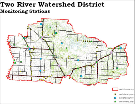
Twenty-eight sites within the watershed have been developed for stream flow monitoring. A staff gage is erected at each site, and periodically during runoff events, flow is measured using a flow meter. Using volunteers and District staff, daily water level measurements are recorded. This process records the volume of water that passes through each monitoring site and the velocity of the water. This information is extremely valuable for predicting flood events and also for modeling stream flows. Eventually a rating curve will be developed for each site and a hydrologic flow model will be developed for the District. Since the inception of this monitoring program in 1996, the District has collected a significant amount of data and has been documenting how water moves through the intricate system of field ditches, road ditches, legal ditches, coulees, streams, river channels and other waterways from upstream to downstream.
Water Quality Data
The District monitors water quality at 16 sites within the District. These sites are established along the main branches of the Two River, along intermittent coulee systems, and along some ditch systems. The purpose of the program is to monitor water quality to document what the base line conditions that are present in the water courses. Parameters that are tested include pH, water temperature, dissolved oxygen, nitrogen, phosphorous, alkalinity, chloride, turbidity, conductivity, and various other indicators of water quality.
Two Rivers Resource Conditions
Other Data Collected by Two Rivers Watershed District
Snow Survey
Each year during the month of February or March, the District performs a snow survey at 10 sites within the District. This survey consists of sampling the snow column and recording the depth of snow and the water content. This information is vital to helping predict the amount of runoff that each area of the District will produce during the spring runoff. The information is recorded and forwarded to the National Weather Service to be included in their database and used in their spring flood forecasts.
Flood Data
During spring snowmelt and also during runoff events from summer storms, the District published and sent out a daily flood statement. This document contained river stage and crest information collected from the stream flow and stream monitoring network. The document was distributed to media, government agencies, and general public upon request.
RBDIN
Culvert Inventory: info pending