Klondike Clean Water Retention Project #11

About Klondike Clean Water Retention Project #11
Description/Location: The 7,600 acre multi-purpose resource project is located 10 miles east of the City of Lake Bronson, MN and 4 miles north, covering nearly 12 square miles on the Kittson and Roseau County line. It is planned to have gated storage of up to 35,250 acre feet from a 191.5 square mile upstream drainage area, include 8 miles of diked inlet channel, up to 6 miles of diversion channels, a 17 mile long dike, and an average dike height of 6 feet.
Problem: Large scale overland flooding is a common occurrence from the City of Badger and west to the Kittson & Roseau County line along 18 linear miles of Lateral 1 of State Ditch 95. Undersized channel capacity and the slope of the landscape contributes to out of bank flows and overland flooding on a large scale. In large flood events, water overflows out of the Roseau River and enters the Two Rivers Watershed District via State Ditch #72, exacerbating the problems. Impacts occur to public roads and infrastructure, loss of agricultural crops, and farmsteads. Roads can be closed for several weeks at a time.
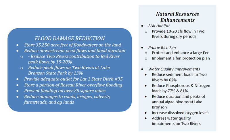
Project Benefits:
A Project Work Team consisting of representatives of local (County, Watershed District, City, Township), state (DNR, BWSR, MPCA) and federal (NRCS, USFWS, USCOE) agencies as well as local landowners and non-government groups (Nature Conservancy, International Water Institute) was convened. This project team met monthly over the course of several years to discuss the project, set goals and investigate alternatives. These meetings followed the process recommended by the Red River Flood Damage Reduction Work Group, which has endorsed the project. This ensures that the project will achieve both flood damage reduction and natural resources enhancement goals and follow proper environmental review procedures.
Status and Timeline
Final Plans and Specifications are 90% complete
Permitting in progress - potentially complete by June 2024 (EAW is done, USCOE, WCA, SHPO, 103E ditches, Others)
Phase 1 – 16,500 acre ft; fish habitat & water quality – 2024-2026
Phase 2 – raise to 27,500 acre ft; fen protection – target 2026-2028
Phase 2A - raise to 35,250 acre ft; – target 2029-2030
Funding needs
Project Design/Permitting/Right of Way is $7.2M
Phase 1 Construction estimate is $13M - $17.5M
Phase 2 Construction estimate is $7M - $9.4M
Phase 3 Construction estimate is $5M - $6.7M
Total Cost = $32.2M - $42M
Funding secured to date: $2.8 M (LSOHC) $7.2 M (RRWMB) $0.5 M State of MN
THESE ARE ESTIMATES - NUMBERS ARE SUBJECT TO CHANGE AS PROJECT DEVELOPS FURTHER
Project Component Fact Sheets:
For a copy of KCRWP11 Fact Sheet 11-1-23, click here.
For a copy of KCWRP HEI Construction Review & Fact Sheets 2023, click here.
For a copy of KCRWP 11 Fact Sheet 1-23-24, click here.
01 - Lat 8 SD 72 Mel Wang Pipe 12-18-23
02 - Lat 6 SD 72 Huseby Pipe 12-18-23
03 - Exterior Drainage for SD 72
09 - Lat 1 SD 95 Upstream Improvements
11 - Exterior Drainage for SD 95
Phases:
Preliminary Work: Preferred alternative; Engineer’s Report; Final Plans & Specifications; Obtain Right of Way; Obtain Permits; Obtain Funding; Cost $7.2 Million
Phase 1: Construct dikes to impound 16,500 acre feet; Construct Pilot Channel; Construct 2 outlet structures & spillways; Construct inlet channel; Construct 2 inlet structures; Cost between $13 Million & $17.5 Million
Phase 2: Construct/raise dikes to impound 26,750 acre feet; Further work on the diked inlet and road; Cost between $7 Million & $9.4 Million
Phase 3: Construct/raise dikes to impound 35,250 acre feet; Construct 4 mile inlet/diversion channel; Cost between $5 Million & $6.7 Million
Expected Flood Reduction:
Computer models were developed by project engineers to compare the flooding prior to the project with expected flooding after the project. These maps show the difference for the 5 year, 10 year, 25 year and 50 year flood events.