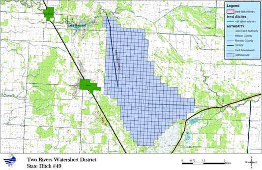
State Ditch #49
About State Ditch #49
Miles: 5.25
Township(s)/County: Norway and Kittson
Ditch Balance: -$30,350
2024 Levy: 0
Constructed – 1907
Recent maintenance - Surveyed (2023), Sprayed (2020)
Recent maintenance - Beaver Removal, Vegetation spraying
Typical Section – 6 foot bottom width, 2 to 1 side slopes
Ditch Grade – Stations 0 to 200 = 0.025% Stations 200 to outlet ≤ 0.08%
This ditch is 5.25 miles in length, begins at County State Aid Highway #7 (Kittson County) 2.5 miles east of Halma, Minnesota and travels northwest through parts of Norway and Percy Townships of Kittson County. The ditch outlet is the South Branch of the Two Rivers at a location just east of Lake Bronson.
This system is inspected annually and
maintenance activities are undertaken if deemed
necessary. These activities range from beaver dam removal and beaver trapping to spraying of cattail and
other nuisance vegetation to removal of silt and sediment to repair of sloughed side slopes or eroded
culverts. Detailed maintenance reports are kept and filed each year in the ditch file.
The District as the ditch authority for these ditches is also responsible for maintaining a ditch fund to pay
for maintenance expenses. Each year the District assesses
the needs of each ditch and a tax is levied
against the "benefited area" of each ditch, if necessary and if the funding is needed. Each year the
District certifies this levy to the County Auditor of the County where the ditch is located.